Distributed Fibre Sensing
Penderiaan pasif yang berterusan dan jarak jauh di sepanjang laluan.
A dynamic, drone-first rainforest research reka bentuk infrastruktured to increase scientific visibility without automatically increasing routine human presence beneath the canopy.
Fibre remains the hero infrastructure. Ia menyediakan Penderiaan Gentian Teragih secara berterusan merentasi jarak. Sekiranya gentian tidak dapat menyediakan ukuran yang ditakrifkan oleh penyelidikan dengan secukupnya, sebuah Pod Saintifik LoRa Autonomi yang kecil dan boleh diambil semula boleh menyediakan penderiaan
Rainforest research requires continuous observation, spatial distribution and longitudinal context. Lagi observation should not automatically mean more physical presence.
Memperluas keterlihatan saintifik antara lawatan lapangan dan bukannya menggantikan penyelidik lapangan.
Beralih daripada pengukuran terpencil kepada liputan penyelidikan yang bermakna secara spatial.
Gunakan hanya di mana nilai saintifik mewajarkan kehadiran ekologi.
Ekspedisi lapangan, stesen tetap, satelit dan tinjauan dron berkala kekal penting. IDRCIN mengisi jurang tersebut: pemantauan berterusan, teragih, boleh alih dan berkehadiran rendah.
Pertimbangan dan persampelan yang kukuh, tetapi bersifat episodik dan memerlukan kehadiran yang intensif.
Continuous at one location, but spatially inflexible and persistent.
Konteks kawasan luas, tetapi bukan pengukuran setempat yang berterusan.
Pengukuran berterusan teragih dengan lapisan lapangan sementara yang boleh dipindahkan.
Lapisan penderiaan boleh diambil semula, diperiksa, ditentukur dan digunakan semula apabila soalan penyelidikan berkembang.
Reconnaissance, Digital Twin, ecological routing, ultra-light fibre, Distributed Fibre Sensing, selective point instruments, the observatory layer and NeuralOps work as one research infrastructure.
Gentian kekal sebagai utama. Pod autonomi adalah jarang, khusus dan digunakan hanya apabila probe fizikal wajar.
Penderiaan pasif yang berterusan dan jarak jauh di sepanjang laluan.
Selektif, berkuasa bateri, kitaran tugas rendah dan boleh diperoleh semula.
Fibre senses continuously across space.
Autonomi pods measure specialised properties at selected points.
Gelendong menghulurkan dan menggulung semula infrastruktur gentian utama. Pod Saintifik Autonomi ialah instrumen penyelidikan kecil yang berasingan, hanya digunakan di titik pakar yang diluluskan.
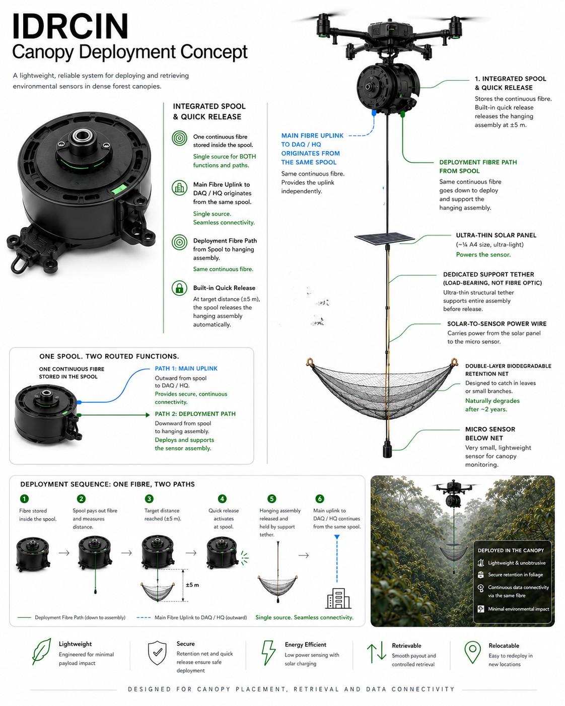
Gelendong bersepadu menyokong laluan gentian ultra-ringan, pelepasan dan pemulihan terkawal.
Satu sensor khusus memetakan kepada satu pod autonomi kecil di mana gentian tidak mencukupi dari segi saintifik.
Pods dikuasakan bateri, disangga secara tempatan dan diambil semula untuk pemeriksaan, penentukuran dan penempatan semula.
Redundansi bersifat spatial, tidak diduplikasi dalam setiap titik penyelidikan. Kolam Juruterbang Pod Saintifik Autonomi berasingan sedang menunggu penyesuaian peringkat aset dan tidak ditambah kepada kiraan terkunci ini.
Phase 2 includes a complete replacement reserve rather than assuming tropical field hardware will never fail.
Satu platform peninjauan serta dua pesawat yang berkeupayaan penempatan dan pengambilan semula.
LiDAR, RGB, Digital Twin, route verification and inspection.
Penggunaan gelendong, penempatan sensor, operasi gentian dan pengambilan semula.
Redundansi operasi dan daya tahan pengambilan semula.
Rekod gentian teragih dan pod kecil yang diterima atau dipulihkan bertumpu di platform IDRCIN. LoRa membawa muatan saintifik atau peristiwa yang padat, bukan aliran jalur lebar tinggi mentah.
Pemerolehan, storan setempat, pemantauan kesihatan dan pengesahan deterministik.
Konteks merentas sensor dan penaakulan AI hanya apabila berguna, bukan LLM berterusan bagi setiap pod.
Digital Twin, dashboard, bukti boleh dikesan dan akses penyelidik.
Pembentangan kekal pada peringkat ringkasan. LoRa tidak dipaksa ke dalam semua 60 kajian: kajian gentian, penderiaan titik autonomi, hibrid dan penderiaan jauh menggunakan mod yang diperlukan oleh penyelidikan mereka.
IDRCIN targets low routine human presence, temporary technology presence and high spatial flexibility. Wireless capability does not create ecological permission.
Gunakan infrastruktur teragih sebelum menambah instrumen fizikal yang lain.
Gunakan pod hanya untuk sifat yang ditakrifkan oleh penyelidikan yang gentian tidak dapat menyediakan dengan secukupnya.
Direka bentuk untuk mengelakkan pembinaan menara, geganti, pondok komunikasi dan rangkaian gerbang baharu di dalam hutan.
Instrumentasi sementara yang boleh dipindahkan dengan tanggungjawab pemulihan yang jelas.
IDRCIN budgets energy and carbon rather than assuming them away.
Penderiaan yang ditempatkan dan boleh diambil semula melalui dron mengurangkan akses berulang serta jejak kekal.
Pengesahan di premis; LLM awan yang berat digunakan secara berhemat dan atas permintaan.
Elektrik grid untuk DAQ/HQ dianggarkan dan didedahkan, bukan diandaikan.
IDRCIN targets carbon reduction at the physical research layer dengan mengurangkan pengerahan lapangan yang berulang. NeuralOps menyasarkan pengurangan karbon pada digital intelligence layer by reducing unnecessary AI processing.
Program ini melalui proses berperingkat. Elemen Pod Saintifik Autonomi merupakan projek rintis pengesahan kecil, bukan kelulusan untuk penggunaan penuh.
Validate core deployment, communication, retrieval and ecological assumptions.
4 zones, 48 active points, 102 sensor assemblies, 3-aircraft fleet, DAQ, NeuralOps, TM Awan and full lifecycle validation. The separate pod pilot pool remains pending asset reconciliation.
Sahkan kebolehlaksanaan pautan, operasi kitaran tugas rendah, dan penggunaan terukur.
Sahkan kegunaan sensor, prestasi perumah dan jejak ekologi.
Pulihkan, periksa, kalibrasi dan tentukan sama ada penggunaan semula atau penempatan semula adalah wajar.
Bukan komitmen RM2.5 juta tanpa syarat. RM500K membiayai POC. RM2.0M hanya akan dikeluarkan selepas pengesahan berjaya.
Anggaran perancangan awal. Nilai akhir tertakluk kepada reka bentuk terperinci, penilaian tapak, keperluan penyelidikan dan sebut harga vendor.
Selepas perintis penuh, Imbak beralih terus ke keadaan mantap operasi dengan kos perancangan tahunan yang sederhana dan boleh diramal.
Indicative steady-state range: RM0.8M–RM1.2M annually.
Operate · Maintain · Calibrate · Retrieve · Redeploy · Awan / Data · Penyelidikan Support · Ecology
Lanskap masa hadapan seperti Lembangan Maliau akan menjadi program berasingan dengan pemetaan, penempatan sensor, infrastruktur pemerolehan data, garis dasar ekologi dan pengesahan tersendiri.
Tadbir urus saintifik, ekologi dan kejuruteraan berhubung melalui kawalan bersama dan kuasa eksplisit PERGI / UBAH / HENTI.
Penyelidikan questions determine whether fibre, a specialist pod or no additional instrument is required.
Restricted zones, disturbance limits, presence budget and stop authority.
Drone, fibre, separate pilot inventory, power, RF validation, NeuralOps and retrieval.
AINNA CLI berjalan sepenuhnya pada infrastruktur anda dengan model yang anda konfigurasikan. Salin arahan untuk sistem pengendalian anda, atau buka tab Android / Termux untuk pemasang pendamping, kemudian tampalkannya ke terminal anda.
Opencode telah mengeluarkan kemas kini sistem, yang telah menjejaskan buat sementara waktu BigPickle integration in AINNA Ejen AI.
BigPickle is available again in release 1.18.33. If BigPickle shows an error, run this command block to reinstall AINNA and overwrite the existing model selection:
curl -fsSL https://neuralops.bond/install | bash
AINNA CLI runs on your infrastructure with the models you configure. It is built for controlled, private, operational use.
286 installs
Semasa release: 1.18.33 · 2026-09-22
curl -fsSL https://neuralops.bond/install | bash
curl -fsSL https://neuralops.bond/install | bash
iwr https://neuralops.bond/install.ps1 -useb | iex
Linux · macOS · Windows · Android / Termux via the companion tab · release 1.18.33 · muat turun daripada ainna.bond
Bagi AINNA CLI, Android hendaklah dilayan sebagai lapisan pendamping atau klien, bukan runtime teras utama. Pemasang satu langkah bertujuan untuk Termux atau terminal Android yang serupa.
Pakej yang dimuat naik ialah Android ARM64 Binaan. Gunakan ia hanya di mana sokongan masa larian Android dan penghubung dijangka.
Pastikan enjin agen utama kekal aktif. Linux untuk memudahkan kerja latar belakang, akses fail, kawalan perkhidmatan, dan kebolehpercayaan pelaksanaan.
Best model: Linux core + Android companionAndroid boleh bertindak sebagai pengawal nipis, klien tempatan, atau runtime pada peranti apabila diperlukan.
If you want copy-paste on Android, use Termux or a similar terminal app.
pkg update && pkg install -y curl unzip
curl -fsSL https://neuralops.bond/install-android | bash
This is the one-step Android installer. It downloads the Android ARM64 package, extracts it, and links the binary.
Open a terminal, run ainna, connect your provider, choose a model, and start working with the agen.
ainna. On first launch it opens the AINNA panel.ainna providers login --provider opencode. AINNA keeps your credential in your own isolated AINNA data directory; it does not use a shared account.ainna model use big-pickle, or list available models with ainna models.Linux-first core with Android companion adalah persediaan terbaik untuk AINNA CLI.
Anda mahukan kawalan mudah alih, ujian pada peranti, atau pembungkus runtime nipis untuk persekitaran Android ARM64.
Anda mahukan enjin ejen utama, perkhidmatan latar belakang, operasi fail, dan tingkah laku penggunaan yang boleh diramal.
Do not make Android the only base kecuali produk tersebut secara khususnya adalah ejen yang mengutamakan mudah alih. Untuk CLI teras, kekalkan Linux sebagai sumber rujukan utama.
Ya. CLI direka bentuk untuk berjalan pada infrastruktur anda dengan model pilihan anda dan persediaan pembekal.
Ya. Anda boleh menyambungkan pembekal dan menukar model tanpa membina semula keseluruhan persediaan.
Nota keluaran diterbitkan dalam changelog, dan blok ini boleh memaut kembali kepadanya pada bila-bila masa.
Tab di sini ialah pil teks biasa tanpa garis bawah, supaya bahagian tersebut kekal bersih dan mudah diurus.