Distributed Fibre Sensing
Continuous observation across distance using the ultra-light fibre infrastructure.
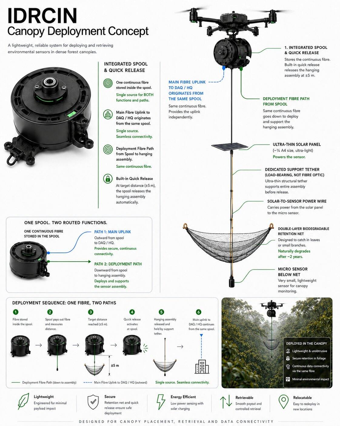
IMBAK Dynamic kanopi Penyelidikan & Intelligence Rangkaian (IDRCIN) a drone-first, retrievable and relocatable scientific infrastructure for continuous rainforest understanding.
In plain words: a drone maps the forest and lays an ultra-light fibre-optic backbone untuk penderiaan teragih. Di mana gentian tidak dapat mengukur sifat yang diperlukan dengan secukupnya, sebilangan kecil yang boleh diperoleh semula Autonomi LoRa Scientific Pods boleh menyediakan pengukuran titik khusus tanpa mewujudkan infrastruktur gerbang darat baharu di dalam hutan terlindung.
IDRCIN is not proposed to add more technology to Imbak Canyon. It uses a Fibre-First Seni Bina, adding selective point instruments only when a research requirement cannot be adequately met through fibre or remote observation.
Imbak Canyon diutamakan sebagai persekitaran pemuliharaan dan penyelidikan. Teknologi kekal tunduk kepada keutamaan saintifik dan ekologi.
Sains lapangan tetap penting apabila pensampelan fizikal, pertimbangan ekologi atau pengesahan lapangan diperlukan. IDRCIN mengurangkan kehadiran manusia yang tidak perlu; ia tidak menggantikan penyelidik.
Seni bina mengekalkan koridor gentian sebagai utama, ultra-ringan dan boleh dipindahkan. Lapisan Penderiaan Titik Khusus Autonomi memperluas keupayaan penyelidikan hanya di mana prob fizikal wajar secara saintifik.
Continuous observation across distance using the ultra-light fibre infrastructure.
Pod saintifik berkuasa bateri yang jarang, satu sensor khusus bagi setiap pod, digunakan hanya apabila siasatan fizikal diperlukan.
Fibre senses continuously across space. Autonomi pods measure specific properties at selected points.
Infrastruktur Gerbang Daratan Baharu Sifar: tiada menara gerbang, pengulang, jejaring, pondok komunikasi atau stesen wayarles perantaraan kekal baharu di dalam hutan perlindungan. Penerima sedia ada atau yang diluluskan boleh digunakan jika boleh dilaksanakan dari segi teknikal d
NeuralOps Sistem Berasingan validate distributed fibre streams and received or recovered pod records. Deterministic checks run first; AI reasoning is used only where it adds research value.
Pengukuran asal dikekalkan, termasuk rekod pod yang disangga secara tempatan yang diterima kemudian melalui radio atau pengambilan semula.
Hingar, pendua, isu cap masa, hanyutan dan nilai mencurigakan ditandakan melalui peraturan yang boleh diaudit.
Corak sejarah, diterima dan tertunda boleh menjana unjuran nasihat dengan keyakinan, andaian dan ufuk masa yang ditunjukkan.
Sistem ini tidak mendakwa impak sifar. Ia mengemukakan persoalan yang lebih mendalam: kaedah manakah yang menghasilkan nilai saintifik yang diperlukan dengan jumlah gangguan ekologi keseluruhan yang paling rendah secara munasabah?
Penempatan, pemeriksaan dan pengambilan rutin direka untuk operasi dron, manakala kerja lapangan manusia kekal tersedia apabila sains atau keselamatan memerlukannya.
Set sensor boleh berputar antara zon penyelidikan selepas enam atau dua belas bulan, memperluas liputan kumulatif tanpa instrumentasi kekal di setiap tapak.
IDRCIN accounts for presence, energy and carbon honestly measured, not assumed.
Instrumentasi yang diterjunkan oleh dron, yang boleh diambil semula atau dipindahkan, dapat mengurangkan akses manusia yang berulang, manakala bateri pod, elektronik dan misi pengambilan semula kekal sebagai sebahagian daripada jejak yang diukur.
Pengesahan dijalankan di premis melalui NeuralOps Detached Sistem; LLM awan yang berat digunakan secara berhemat, memastikan tenaga dan karbon berkadar dengan keperluan.
IDRCIN targets carbon reduction at the physical research layer dengan mengurangkan pengerahan lapangan yang berulang. NeuralOps menyasarkan pengurangan karbon pada digital intelligence layer by reducing unnecessary AI processing.
Setiap kelebihan dipasangkan dengan keterbatasannya serta strategi tindak balas. Keteguhan terhasil daripada reka bentuk berlapis, bukan tuntutan kesempurnaan.
Risiko kritikal diterapkan dalam model operasi dan bukannya disembunyikan daripada cadangan tersebut.
IMBAK mengesyorkan ujian rintis kecil untuk Pod Saintifik LoRa Autonomi Fasa 2 sebelum sebarang keputusan skala. Pod kekal sebagai kumpulan instrumen saintifik yang berasingan sehingga penyesuaian peringkat aset selesai.
Kebolehlaksanaan RF, penggunaan bateri, kebolehbertahanan perumah, pengekalan data setempat dan prestasi pengambilan semula.
Sensor accuracy, calibration stability, data completeness, traceability and unique value beyond fibre.
Jejak fizikal, interaksi hidupan liar, intervensi penyelenggaraan dan pemulihan penuh selepas perintis.
IDRCIN is designed to help Yayasan Sabah and research partners understand Imbak Canyon more continuously, more spatially and more intelligently while reducing unnecessary physical intervention wherever practical.
Continuous, spatially distributed scientific knowledge with minimal physical presence beneath the canopy.